John Deere has established a new partnership with Leica Geosystems to provide mobile phone network RTK (NRTK) corrections via the company's dealers in the UK and Ireland, for repeatable, highly accurate(+/-2.5cm) precision farming applications.
John Deere's latest Mobile RTK offering has three different components.The John Deere Mobile RTK Modem provides the connection to the RTK corrections over the mobile phone network. This comes with an open SIM capability, allowing customers to choose their own service provider.
John Deere Mobile RTK Access gives customers access to third party RTK corrections, and allows automatic RTK Extend and satellite-based SF2 signal correction to +/-5cm, to increase reliability during field operations when the mobile phone service is interrupted.
In addition, John Deere's new partnership provides access to the Leica Geosystems NRTK correction service for all agricultural customers in the UK and Ireland. Using this service, Leica Geosystems will be the preferred supplier of Mobile RTK corrections, and provide annual subscriptions through the John Deere dealer network.
Mobile RTK collects information from a synchronised network of GPS reference stations setup across both countries to calculate the correction data. To provide complete geographical coverage, the Leica Geosystems service uses data under licence from reference stations owned by Ordnance Survey Great Britain, Ordnance Survey Ireland and Land & Property Services in Northern Ireland.
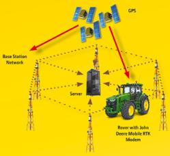
In addition to the satellite GPS signal, Mobile RTK correction data is sourced from a countrywide pool of existing base stations, so users don't need to invest in their own. A centrally located server (see illustration below) calculates the correction signal, which is then transmitted via the mobile phone network to the vehicle, equipped with the John Deere Mobile RTK modemand StarFire3000 receiver. This maintains continuous data connection, even in difficult terrain or across wide geographical areas.